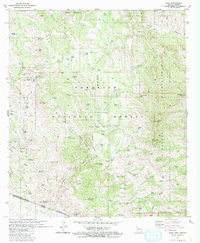
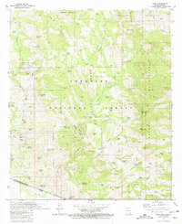
1981 Map of Ruby
USGS Topo · Published 1985About this map
Ruby and its surrounding mining district sit at the heart of the Coronado National Forest, where the complex geology of the Tumacacori Mountains and Atascosa Mountains meets the international border. This survey details a landscape defined by 20th-century extraction, featuring the Montana Mine and Montana Peak, as well as the Cramer Mine and Dos Amigos Mine. The presence of the Oro Blanco Ruins and Ruby Lakes reflects the precarious nature of settlement and water management in this arid borderland.
Find a feature on this map
93 named features on this map. Tap any name to fly to it.
Don’t see what you’re looking for? This feature index may not catch every label — zoom into the map to look around manually.
Map Details
Editions of this 1981 Ruby Map
3 editions found
Historical Maps of Ruby Through Time
108 maps found

1921 Old Glory
Santa Cruz County, AZ

1922 Agus Caliente
Santa Cruz County, AZ

1932 Lochiel
Santa Cruz County, AZ

1933 Calabasas
Santa Cruz County, AZ

1942 Oro Blanco
Santa Cruz County, AZ

1942 Ruby
Santa Cruz County, AZ

1943 Old Glory
Santa Cruz County, AZ

1944 Oro Blanco
Santa Cruz County, AZ

1948 Canelo Pass
Santa Cruz County, AZ

1948 Duquesne
Santa Cruz County, AZ

1948 Harshaw
Santa Cruz County, AZ

1948 Lochiel
Santa Cruz County, AZ

1948 Lochiel SE
Santa Cruz County, AZ

1948 Mt. Hughes
Santa Cruz County, AZ

1948 O'Donnell Canyon
Santa Cruz County, AZ

1957 Ruby
Santa Cruz County, AZ

1958 Canelo Pass
Santa Cruz County, AZ

1958 Duquesne
Santa Cruz County, AZ

1958 Harshaw
Santa Cruz County, AZ

1958 Lochiel
Santa Cruz County, AZ

1958 Lochiel
Santa Cruz County, AZ

1958 Mount Wrightson
Santa Cruz County, AZ

1958 Mt. Hughes
Santa Cruz County, AZ

1958 O'Donnell Canyon
Santa Cruz County, AZ

1979 Bartlett Mtn
Santa Cruz County, AZ

1980 Alamo Spring
Santa Cruz County, AZ

1981 Cumero Canyon
Santa Cruz County, AZ

1981 Mt. Hopkins
Santa Cruz County, AZ

1981 Mt. Wrightson
Santa Cruz County, AZ

1981 Pajarito Peak
Santa Cruz County, AZ

1981 Pena Blanca Lake
Santa Cruz County, AZ

1981 Ruby
Santa Cruz County, AZ

1981 San Cayetano Mts.
Santa Cruz County, AZ

1994 Atascosa Mountains
Santa Cruz County, AZ

1996 Canelo Pass
Santa Cruz County, AZ

1996 Cumero Canyon
Santa Cruz County, AZ

1996 Harshaw
Santa Cruz County, AZ

1996 Mount Hopkins
Santa Cruz County, AZ

1996 Mount Hughes
Santa Cruz County, AZ

1996 Mount Wrightson
Santa Cruz County, AZ

1996 O'Donnell Canyon
Santa Cruz County, AZ

1996 San Cayetano Mountains
Santa Cruz County, AZ

2004 Alamo Spring
Santa Cruz County, AZ

2004 Bartlett Mountain
Santa Cruz County, AZ

2004 Duquesne
Santa Cruz County, AZ

2004 Lochiel
Santa Cruz County, AZ

2004 Pajarito Peak
Santa Cruz County, AZ

2004 Ruby
Santa Cruz County, AZ

2012 Alamo Spring
Santa Cruz County, AZ

2012 Bartlett Mountain
Santa Cruz County, AZ

2012 Canelo Pass
Santa Cruz County, AZ

2012 Cumero Canyon
Santa Cruz County, AZ

2012 Duquesne
Santa Cruz County, AZ

2012 Harshaw
Santa Cruz County, AZ

2012 Lochiel
Santa Cruz County, AZ

2012 Mount Hopkins
Santa Cruz County, AZ

2012 Mount Hughes
Santa Cruz County, AZ

2012 Mount Wrightson
Santa Cruz County, AZ

2012 O'Donnell Canyon
Santa Cruz County, AZ

2012 Pajarito Peak
Santa Cruz County, AZ

2012 Pena Blanca Lake
Santa Cruz County, AZ

2012 Ruby
Santa Cruz County, AZ

2012 San Cayetano Mountains
Santa Cruz County, AZ

2014 Alamo Spring
Santa Cruz County, AZ

2014 Bartlett Mountain
Santa Cruz County, AZ

2014 Canelo Pass
Santa Cruz County, AZ

2014 Cumero Canyon
Santa Cruz County, AZ

2014 Duquesne
Santa Cruz County, AZ

2014 Harshaw
Santa Cruz County, AZ

2014 Lochiel
Santa Cruz County, AZ

2014 Mount Hopkins
Santa Cruz County, AZ

2014 Mount Hughes
Santa Cruz County, AZ

2014 Mount Wrightson
Santa Cruz County, AZ

2014 O'Donnell Canyon
Santa Cruz County, AZ

2014 Pajarito Peak
Santa Cruz County, AZ

2014 Pena Blanca Lake
Santa Cruz County, AZ

2014 Ruby
Santa Cruz County, AZ

2014 San Cayetano Mountains
Santa Cruz County, AZ

2018 Alamo Spring
Santa Cruz County, AZ

2018 Bartlett Mountain
Santa Cruz County, AZ

2018 Canelo Pass
Santa Cruz County, AZ

2018 Cumero Canyon
Santa Cruz County, AZ

2018 Duquesne
Santa Cruz County, AZ

2018 Harshaw
Santa Cruz County, AZ

2018 Lochiel
Santa Cruz County, AZ

2018 Mount Hopkins
Santa Cruz County, AZ

2018 Mount Hughes
Santa Cruz County, AZ

2018 Mount Wrightson
Santa Cruz County, AZ

2018 O'Donnell Canyon
Santa Cruz County, AZ

2018 Pajarito Peak
Santa Cruz County, AZ

2018 Pena Blanca Lake
Santa Cruz County, AZ

2018 Ruby
Santa Cruz County, AZ

2018 San Cayetano Mountains
Santa Cruz County, AZ

2021 Alamo Spring
Santa Cruz County, AZ

2021 Bartlett Mountain
Santa Cruz County, AZ

2021 Canelo Pass
Santa Cruz County, AZ

2021 Cumero Canyon
Santa Cruz County, AZ

2021 Duquesne
Santa Cruz County, AZ

2021 Harshaw
Santa Cruz County, AZ

2021 Lochiel
Santa Cruz County, AZ

2021 Mount Hopkins
Santa Cruz County, AZ

2021 Mount Hughes
Santa Cruz County, AZ

2021 Mount Wrightson
Santa Cruz County, AZ

2021 O'Donnell Canyon
Santa Cruz County, AZ

2021 Pajarito Peak
Santa Cruz County, AZ

2021 Pena Blanca Lake
Santa Cruz County, AZ

2021 Ruby
Santa Cruz County, AZ

2021 San Cayetano Mountains
Santa Cruz County, AZ