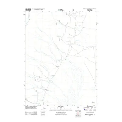
2012 Map of Ruby Valley School
USGS Topo · Published 2012About this map
The Ruby Valley School (historical) serves as a focal point for this Elko County ranching landscape, indicating the long-standing educational roots of this rural Nevada valley. The area is defined by a network of family-held properties including Wines Ranch, Gardner Ranch, and Meyers Ranch, which are situated along the perennial drainages flowing toward Big Meadow. This 2012 survey illustrates the essential role of water in the high desert, mapping features like Sulphur Hot Springs and Watermelon Spring alongside numerous creeks such as Thompson Cr and Colonel Moore Cr. The presence of the Llama Ranch Airport reflects more modern transportation adaptations in this expansive terrain, while the course of Co HWY 788 remains the primary artery connecting these isolated mountain-shadow ranchsteads.
Find a feature on this map
25 named features on this map. Tap any name to fly to it.
Don’t see what you’re looking for? This feature index may not catch every label — zoom into the map to look around manually.
Map Details
Editions of this 2012 Ruby Valley School Map
This is the sole edition of this map. No revisions or reprints were ever made.
Other maps of this area

1935 · Halleck
USGS Topo · 1:125,000

1955 · Elko
USGS Topo · 1:250,000

1958 · Elko
USGS Topo · 1:250,000

1962 · Elko
USGS Topo · 1:250,000

1962 · Lamoille
USGS Topo · 1:62,500

1965 · Elko
USGS Topo · 1:250,000

1968 · Franklin Lake NE
USGS Topo · 1:24,000
1969 · Franklin Lake NW
USGS Topo · 1:24,000
1984 · Ruby City Creek
USGS Topo · 1:24,000

1984 · West of Delcer Buttes
USGS Topo · 1:24,000