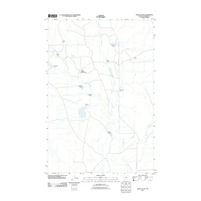
2011 Map of Rudie Coulee
USGS Topo · Published 2011About this map
Little Porcupine Creek and its complex network of seasonal tributaries define this section of Rosebud County, Montana, where the ranching economy is etched into the landscape through dozens of small-scale water management projects. The 2011 topography shows a distinct pattern of land use centered on earthen dams and reservoirs, including the Hanson Company Number 5 Dam, Ulmer Lake Dam, and multiple structures bearing the Standish name. These features suggest a history of coordinated livestock management across the drainage basins of Rudie Coulee and Wildcat Coulee. Sparse infrastructure like Little Porcupine Rd and Road 124 provide the only major access points through this dry, dissected prairie. The naming conventions of the dams, such as VT Number 1 Dam and US Number 3 Dam, reflect the systematic development of water resources in this part of the state.
Find a feature on this map
17 named features on this map. Tap any name to fly to it.
Don’t see what you’re looking for? This feature index may not catch every label — zoom into the map to look around manually.
Map Details
Editions of this 2011 Rudie Coulee Map
This is the sole edition of this map. No revisions or reprints were ever made.
Other maps of this area

1954 · Forsyth
USGS Topo · 1:250,000

1957 · Forsyth
USGS Topo · 1:250,000

1958 · Forsyth
USGS Topo · 1:250,000

1965 · Needle Butte Reservoir
USGS Topo · 1:24,000

1965 · Needle Butte
USGS Topo · 1:24,000

1965 · Stellar Lake
USGS Topo · 1:24,000

1969 · Rudie Coulee
USGS Topo · 1:24,000

1969 · Flat Bottom Coulee NE
USGS Topo · 1:24,000
1969 · Rough Creek SE
USGS Topo · 1:24,000
1969 · Rough Creek SW
USGS Topo · 1:24,000