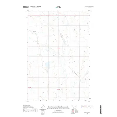
2020 Map of Rudie Coulee
USGS Topo · Published 2020About this map
Rudie Coulee and the surrounding drainage network of Rosebud County characterize this high plains landscape. The terrain is defined by its seasonal watercourses, including the Little Porcupine Cr and its tributaries, the E Fork Little Porcupine Cr and Ryans Fork. The presence of Badland Coulee and Wildcat Coulee suggests the type of eroded, broken ground common in this part of Montana, where the natural topography dictates the few established routes. Transport through this open country is limited to gravel and improved paths such as Little Porcupine Creek Rd, Rd 202, and Rd 124. This survey illustrates the relationship between the dry coulees and the intermittent creek beds that have carved the land over centuries, providing a detailed record of land divisions and topographical elevations in an area defined by its geographic isolation.
Find a feature on this map
13 named features on this map. Tap any name to fly to it.
Don’t see what you’re looking for? This feature index may not catch every label — zoom into the map to look around manually.
Map Details
Editions of this 2020 Rudie Coulee Map
This is the sole edition of this map. No revisions or reprints were ever made.
Other maps of this area

1954 · Forsyth
USGS Topo · 1:250,000

1957 · Forsyth
USGS Topo · 1:250,000

1958 · Forsyth
USGS Topo · 1:250,000

1965 · Needle Butte Reservoir
USGS Topo · 1:24,000

1965 · Needle Butte
USGS Topo · 1:24,000

1965 · Stellar Lake
USGS Topo · 1:24,000

1969 · Rudie Coulee
USGS Topo · 1:24,000

1969 · Flat Bottom Coulee NE
USGS Topo · 1:24,000
1969 · Rough Creek SE
USGS Topo · 1:24,000
1969 · Rough Creek SW
USGS Topo · 1:24,000