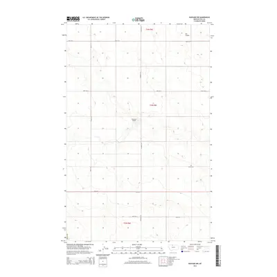
2014 Map of Rudyard NW
USGS Topo · Published 2014About this map
Fourmile Coulee and Big Coulee define the rolling drainage patterns of this high plains landscape in Hill County. The area is characterized by a strict Public Land Survey System grid, with a network of section-line roads including Road 15 N and Inverness Rd providing access to isolated farmsteads. A singular cultural landmark, the Bethel Cem, stands near the intersection of the townships, serving as a focal point for local genealogical interest. The map documents the vast agricultural expanses within t35n r8e, t34n r8e, and t33n r8e, where the interplay between the dry coulees and the engineered road system reveals the enduring settlement patterns of Northern Montana.
Find a feature on this map
13 named features on this map. Tap any name to fly to it.
Don’t see what you’re looking for? This feature index may not catch every label — zoom into the map to look around manually.
Map Details
Editions of this 2014 Rudyard NW Map
This is the sole edition of this map. No revisions or reprints were ever made.
Other maps of this area

1919 · Alma
USGS Topo · 1:125,000

1954 · Shelby
USGS Topo · 1:250,000

1958 · Shelby
USGS Topo · 1:250,000

1963 · Joplin
USGS Topo · 1:24,000

1963 · Bobcat Coulee SE
USGS Topo · 1:24,000

1963 · Chester NE
USGS Topo · 1:24,000
1972 · Rudyard
USGS Topo · 1:24,000

1972 · Goldstone SW
USGS Topo · 1:24,000

1972 · Rudyard NW
USGS Topo · 1:24,000
1972 · Inverness
USGS Topo · 1:24,000