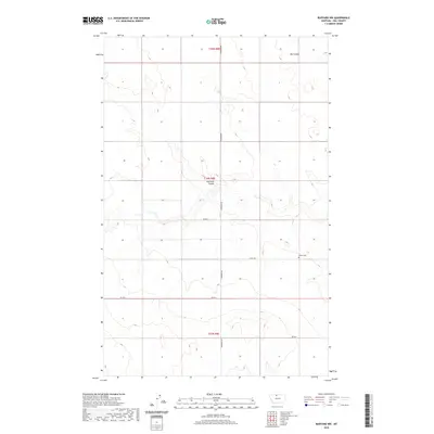
2020 Map of Rudyard NW
USGS Topo · Published 2020About this map
Fourmile Coulee cuts through this rural portion of Hill County, where the landscape is defined by the high plains and systematic land partitions of the Public Land Survey System. The area is marked by large townships including t34n r8e, where isolated landmarks provide the only breaks in the expansive agricultural terrain. In the eastern part of the quadrangle, Bethel Cem sits as a quiet historical marker along the section lines, serving as a primary point of interest for genealogists tracing early families in this part of Montana. The map illustrates a strictly organized network of section-line roads, such as Inverness Rd and Co Rd 70 N, which facilitate movement between the drainages of Big Coulee and the surrounding high ground. This 2020 survey reflects the enduring spatial organization of the northern plains, where natural coulees and precise human geometry coexist.
Find a feature on this map
13 named features on this map. Tap any name to fly to it.
Don’t see what you’re looking for? This feature index may not catch every label — zoom into the map to look around manually.
Map Details
Editions of this 2020 Rudyard NW Map
This is the sole edition of this map. No revisions or reprints were ever made.
Other maps of this area

1919 · Alma
USGS Topo · 1:125,000

1954 · Shelby
USGS Topo · 1:250,000

1958 · Shelby
USGS Topo · 1:250,000

1963 · Joplin
USGS Topo · 1:24,000

1963 · Bobcat Coulee SE
USGS Topo · 1:24,000

1963 · Chester NE
USGS Topo · 1:24,000
1972 · Rudyard
USGS Topo · 1:24,000

1972 · Goldstone SW
USGS Topo · 1:24,000

1972 · Rudyard NW
USGS Topo · 1:24,000
1972 · Inverness
USGS Topo · 1:24,000