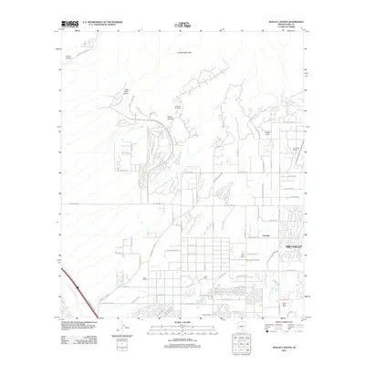
2011 Map of Ruelas Canyon
USGS Topo · Published 2011About this map
The Tortolita Mountains dominate the northern landscape of this Pima County quadrangle, where the desert floor meets the steep drainages of Cochie Canyon and Ruelas Canyon. By the early 21st century, the transition from ranching heritage to suburban expansion is evident in the residential patterns surrounding Tortolita and the northern reaches of Oro Valley. While older operations like the T-Bench-Bar Ranch and Bonnie Brae Ranch represent the area's agricultural roots, the emergence of the La Cholla Airpark and numerous planned road networks across the southwest illustrate the modern character of the region. The ephemeral Santa Cruz River clips the southwestern corner, paralleled by major transport corridors, while the landscape is dotted with several named holdings such as Oasis Ranch and Palo Ferro Ranch, marking the evolution of the desert valley north of Tucson.
Find a feature on this map
71 named features on this map. Tap any name to fly to it.
Don’t see what you’re looking for? This feature index may not catch every label — zoom into the map to look around manually.
Map Details
Editions of this 2011 Ruelas Canyon Map
This is the sole edition of this map. No revisions or reprints were ever made.
Other maps of this area

1904 · Tucson
USGS Topo · 1:125,000

1905 · Tucson
USGS Topo · 1:125,000

1911 · Winkelman
USGS Topo · 1:125,000

1913 · Winkelman
USGS Topo · 1:125,000

1934 · Tucson Mountains
USGS Topo · 1:125,000

1934 · Newman Peak
USGS Topo · 1:125,000

1947 · Cortaro
USGS Topo · 1:62,500

1956 · Tucson
USGS Topo · 1:250,000

1957 · Cortaro
USGS Topo · 1:62,500
1957 · Tucson North
USGS Topo · 1:24,000