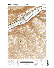
2017 Map of Rufus
USGS Topo · Published 2017About this map
Rufus occupies the southern bank of the Columbia River at a significant hydraulic and geographic transition point. The landscape is defined by the massive presence of the Lake Umatilla and Lake Celilo reservoirs, which are separated by the engineering works of the John Day Dam Road. This area marks the confluence where the John Day River joins the Columbia from the east, creating a complex network of waterways and canyons. The terrain rises sharply from the riverbanks into a series of deeply etched drainages, including Scott Canyon and Gerking Canyon. While the town of Rufus serves as a modern focal point, the map preserves older site names like China Hollow and The Nook, alongside reliable water sources such as Pioneer Spring and Helm Springs that have historically supported life in this arid river corridor.
Find a feature on this map
41 named features on this map. Tap any name to fly to it.
Don’t see what you’re looking for? This feature index may not catch every label — zoom into the map to look around manually.
Map Details
Editions of this 2017 Rufus Map
This is the sole edition of this map. No revisions or reprints were ever made.
Other maps of this area

1953 · The Dalles
USGS Topo · 1:250,000

1956 · The Dalles
USGS Topo · 1:250,000

1957 · The Dalles
USGS Topo · 1:250,000

1957 · Wasco
USGS Topo · 1:62,500

1957 · Goldendale
USGS Topo · 1:62,500

1957 · Wishram
USGS Topo · 1:62,500

1957 · Satus Pass
USGS Topo · 1:62,500

1971 · Quinton
USGS Topo · 1:24,000
1971 · Klondike
USGS Topo · 1:24,000

1971 · Rufus
USGS Topo · 1:24,000