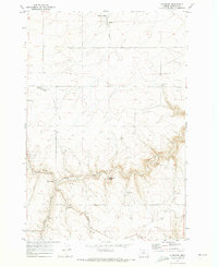
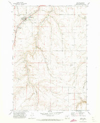
1971 Map of Klondike
USGS Topo · Published 1973About this map
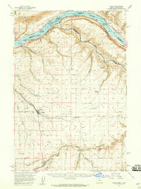
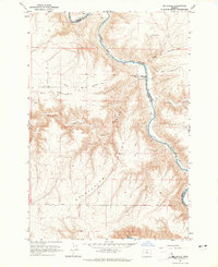
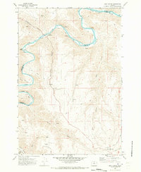
The small grain-loading settlement of Klondike serves as a focal point in this 1970s landscape of Sherman County, characterized by high plateau wheat farming and deep drainage systems. The map depicts a transitional period where transportation infrastructure was shifting, evidenced by the prominent Old Railroad Grade and a network of Jeep Trails carving through the terrain. Agricultural industry is localized at features like the Grain Elevator in Klondike and Storage Bins scattered near the Base Line, while the topography is defined by the winding course of Grass Valley Canyon and the prominent Beavertail Butte. Smaller landmarks like Webfoot and the remote Emigrant Springs provide essential orientation points for local history researchers tracing the development of the Oregon high country. This survey also records various resource extraction points, including several Gravel Pits and a Borrow Pit, reflecting the ongoing maintenance of the rural road network.
Find a feature on this map
26 named features on this map. Tap any name to fly to it.
Don’t see what you’re looking for? This feature index may not catch every label — zoom into the map to look around manually.
Map Details
Editions of this 1971 Klondike Map
This is the sole edition of this map. No revisions or reprints were ever made.
Other maps of this area

1916 · Arlington
USGS Topo · 1:125,000

1916 · Condon
USGS Topo · 1:125,000

1953 · The Dalles
USGS Topo · 1:250,000

1956 · The Dalles
USGS Topo · 1:250,000

1957 · The Dalles
USGS Topo · 1:250,000
1957 · Wasco
USGS Topo · 1:62,500
1964 · Mc Donald
USGS Topo · 1:24,000
1970 · Esau Canyon
USGS Topo · 1:24,000
1971 · Moro
USGS Topo · 1:24,000
1971 · Quinton
USGS Topo · 1:24,000