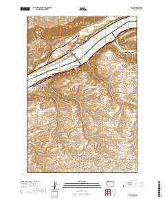
2020 Map of Rufus
USGS Topo · Published 2020About this map
Rufus occupies a strategic position on the southern bank of the Columbia River, situated between the expansive waters of Lake Celilo and Lake Umatilla. This modern survey illustrates the complex geography of the region, where the John Day River joins the Columbia at a point marked by The Nook and Preachers Eddy. The landscape is defined by deep incisions into the plateau, creating a series of dramatic landforms such as Hellroaring Canyon, Pyburn Hollow, and Scott Canyon.
Find a feature on this map
38 named features on this map. Tap any name to fly to it.
Don’t see what you’re looking for? This feature index may not catch every label — zoom into the map to look around manually.
Map Details
Editions of this 2020 Rufus Map
This is the sole edition of this map. No revisions or reprints were ever made.
Other maps of this area

1953 · The Dalles
USGS Topo · 1:250,000

1956 · The Dalles
USGS Topo · 1:250,000

1957 · The Dalles
USGS Topo · 1:250,000

1957 · Wasco
USGS Topo · 1:62,500

1957 · Goldendale
USGS Topo · 1:62,500

1957 · Wishram
USGS Topo · 1:62,500

1957 · Satus Pass
USGS Topo · 1:62,500

1971 · Quinton
USGS Topo · 1:24,000
1971 · Klondike
USGS Topo · 1:24,000

1971 · Rufus
USGS Topo · 1:24,000