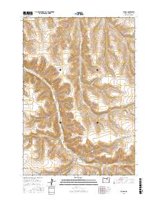
2017 Map of Ruggs
USGS Topo · Published 2017About this map
Ruggs sits at the junction of several canyon systems in southern Morrow County, where the high plateaus are bisected by Rhea Cr. The landscape is defined by its deep drainages and elevated flats, such as Social Ridge and Cason Canyon. This 2017 survey by the U.S. Geological Survey captures a sparsely populated region primarily organized around ranching and transit corridors, indicated by labels like Stock Drive Rd and Rhea Creek Rd. Water sources remain critical in this environment, with Als Spring and Spring Hollow Cr providing rare relief in the dry terrain. The map serves as a record of the enduring road network and the natural topographical barriers, including Clarks Canyon and Fuller Canyon, that have dictated movement through this part of the Oregon interior for generations.
Find a feature on this map
23 named features on this map. Tap any name to fly to it.
Don’t see what you’re looking for? This feature index may not catch every label — zoom into the map to look around manually.
Map Details
Editions of this 2017 Ruggs Map
This is the sole edition of this map. No revisions or reprints were ever made.
Other maps of this area

1953 · Pendleton
USGS Topo · 1:250,000

1956 · Pendleton
USGS Topo · 1:250,000

1968 · Swaggart Buttes
USGS Topo · 1:24,000

1968 · Lexington
USGS Topo · 1:24,000

1968 · Eightmile
USGS Topo · 1:24,000

1968 · Ruggs
USGS Topo · 1:24,000

1968 · Ione South
USGS Topo · 1:24,000

1968 · Heppner
USGS Topo · 1:24,000

1969 · Buttermilk Canyon
USGS Topo · 1:24,000

1969 · Hardman
USGS Topo · 1:24,000