
1968 Map of Swaggart Buttes
USGS Topo · Published 1970About this map
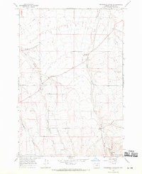
Swaggart Buttes rises as a prominent landmark in this section of Morrow County, defining a landscape carved by an intricate network of ephemeral drainages. The Union Pacific railroad corridor follows the path of Willow Creek in the southwestern corner, marking the primary transportation artery for the region during the late 1960s. Near the western edge, the small settlement of Rieper sits at the head of a canyon system, while agricultural infrastructure like Storage Bins and a Radio Tower indicate the land's utility for ranching and communication. The map reveals the stark topography of the Oregon high country, where named draws such as Blackhorse Canyon, Sourdough Canyon, and Sand Hollow converge to shape the rugged geography between the buttes and the rail line.
Find a feature on this map
20 named features on this map. Tap any name to fly to it.
Don’t see what you’re looking for? This feature index may not catch every label — zoom into the map to look around manually.
Map Details
Editions of this 1968 Swaggart Buttes Map
This is the sole edition of this map. No revisions or reprints were ever made.
Other maps of this area

1906 · Blalock Island
USGS Topo · 1:125,000

1908 · Blalock Island
USGS Topo · 1:125,000

1908 · Umatilla
USGS Topo · 1:125,000

1953 · Pendleton
USGS Topo · 1:250,000

1956 · Pendleton
USGS Topo · 1:250,000

1968 · Lexington
USGS Topo · 1:24,000

1968 · Ruggs
USGS Topo · 1:24,000

1968 · Gleason Butte
USGS Topo · 1:24,000

1968 · Butter Creek Junction
USGS Topo · 1:24,000
1968 · Strawberry Canyon SE
USGS Topo · 1:24,000