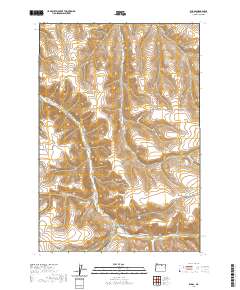
2020 Map of Ruggs
USGS Topo · Published 2020About this map
Ruggs sits at the junction of several canyon roads in this high-desert landscape of eastern Oregon. The settlement is defined by its position along the meandering Rhea Cr, where the valley floor provides a narrow corridor for transit between steep ridges. To the east, Social Ridge stands as a prominent geographic landmark, separating the main creek drainage from the systems of Clarks Canyon and Fuller Canyon. This interior portion of Morrow County shows a land use pattern dominated by livestock and resource management, evidenced by routes like Stock Drive Rd and Stock Drive Ln. Local water sources, vital for survival in this arid terrain, include Als Spring and the drainage of Spring Hollow Cr. The map details a network of family-named roads and mountain passes that have connected these isolated homesteads for generations.
Find a feature on this map
22 named features on this map. Tap any name to fly to it.
Don’t see what you’re looking for? This feature index may not catch every label — zoom into the map to look around manually.
Map Details
Editions of this 2020 Ruggs Map
This is the sole edition of this map. No revisions or reprints were ever made.
Other maps of this area

1953 · Pendleton
USGS Topo · 1:250,000

1956 · Pendleton
USGS Topo · 1:250,000

1968 · Swaggart Buttes
USGS Topo · 1:24,000

1968 · Lexington
USGS Topo · 1:24,000

1968 · Eightmile
USGS Topo · 1:24,000

1968 · Ruggs
USGS Topo · 1:24,000

1968 · Ione South
USGS Topo · 1:24,000

1968 · Heppner
USGS Topo · 1:24,000

1969 · Buttermilk Canyon
USGS Topo · 1:24,000

1969 · Hardman
USGS Topo · 1:24,000