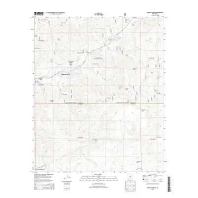
2013 Map of Ruidoso Downs
USGS Topo · Published 2013About this map
Ruidoso Downs and Ruidoso sit at the northern edge of this high-elevation landscape, where the Rio Ruidoso flows past the Herrera Ditch toward the eastern plains. Much of the southern terrain is dominated by the Lincoln National Forest and the northern reaches of the Sacramento Mountains, a region defined by steep drainages like Grapevine Canyon and Cook Canyon. Cultural landmarks are scattered throughout the rugged topography, including the Stetson Cem near Palo Verde Canyon and the high summit of Whitetail Mtn to the south. The mapping reveals a network of water management features essential for the arid environment, from the Seeping Springs Lakes to numerous livestock tanks such as Red Bluff Tank and No Water Tank. Tribal lands are indicated by Indian Service Route 70, which winds through the southern high country near Bear Spring.
Find a feature on this map
48 named features on this map. Tap any name to fly to it.
Don’t see what you’re looking for? This feature index may not catch every label — zoom into the map to look around manually.
Map Details
Editions of this 2013 Ruidoso Downs Map
This is the sole edition of this map. No revisions or reprints were ever made.
Other maps of this area

1955 · Roswell
USGS Topo · 1:250,000

1958 · Roswell
USGS Topo · 1:250,000

1961 · Lincoln
USGS Topo · 1:62,500

1962 · Roswell
USGS Topo · 1:250,000

1963 · Fort Stanton
USGS Topo · 1:24,000

1963 · Ruidoso Downs
USGS Topo · 1:24,000

1963 · Ruidoso
USGS Topo · 1:24,000

1963 · Angus
USGS Topo · 1:24,000
1963 · Pajarita Mountain
USGS Topo · 1:24,000

1963 · Apache Summit
USGS Topo · 1:24,000