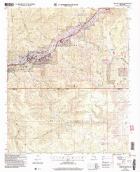
2004 Map of Ruidoso Downs
USGS Topo · Published 2006About this map
The Ruidoso Downs Race Track serves as a major focal point for the community of Ruidoso Downs, where the high-altitude landscape of the Sierra Blanca meets the valley floor along the Rio Ruidoso. This 2004 revision reveals the intricate boundary between the Lincoln National Forest and the Mescalero Apache Indian Reservation, highlighting the intersection of federal, tribal, and private lands. The settlement of Palo Verde and the Stetson Cem offer localized points of interest for genealogists tracing family histories in Lincoln County.
Find a feature on this map
43 named features on this map. Tap any name to fly to it.
Don’t see what you’re looking for? This feature index may not catch every label — zoom into the map to look around manually.
Map Details
Editions of this 2004 Ruidoso Downs Map
This is the sole edition of this map. No revisions or reprints were ever made.
Other maps of this area

1955 · Roswell
USGS Topo · 1:250,000

1958 · Roswell
USGS Topo · 1:250,000

1961 · Lincoln
USGS Topo · 1:62,500

1962 · Roswell
USGS Topo · 1:250,000

1963 · Fort Stanton
USGS Topo · 1:24,000

1963 · Ruidoso Downs
USGS Topo · 1:24,000

1963 · Ruidoso
USGS Topo · 1:24,000

1963 · Angus
USGS Topo · 1:24,000
1963 · Pajarita Mountain
USGS Topo · 1:24,000

1963 · Apache Summit
USGS Topo · 1:24,000