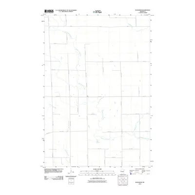
2010 Map of Rum River
USGS Topo · Published 2010About this map
The West Branch Rum River and the main stem of the Rum River dominate this portion of Mille Lacs County, flowing through a landscape defined by its intricate drainage patterns and grid-based rural infrastructure. The 2010 survey illustrates a region where water and land use are deeply intertwined, with the Saint Francis River and Tibbetts Brook feeding into the local watershed. The presence of numerous township roads and county routes, such as County Hwy-67 and Twp Hwy 311, reveals a highly organized agricultural or residential grid typical of Central Minnesota. This network of thoroughfares, including Ronneby Rd Ne and Sage Rd, provides a clear view of how property was divided and accessed at the start of the 21st century. Geographers and local historians can use these precise alignments to trace the development of rural tracts between the various branches and brooks that cross the quadrangle.
Find a feature on this map
37 named features on this map. Tap any name to fly to it.
Don’t see what you’re looking for? This feature index may not catch every label — zoom into the map to look around manually.
Map Details
Editions of this 2010 Rum River Map
This is the sole edition of this map. No revisions or reprints were ever made.
Other maps of this area

1953 · Stillwater
USGS Topo · 1:250,000

1955 · Stillwater
USGS Topo · 1:250,000

1958 · Stillwater
USGS Topo · 1:250,000

1965 · Stillwater
USGS Topo · 1:250,000

1968 · Ramey NE
USGS Topo · 1:24,000
1968 · Foley
USGS Topo · 1:24,000
1968 · Ramey NW
USGS Topo · 1:24,000

1968 · Rum River
USGS Topo · 1:24,000
1968 · Ramey
USGS Topo · 1:24,000

1968 · Milaca
USGS Topo · 1:24,000