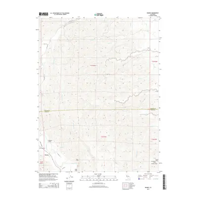
2015 Map of Rumsey
USGS Topo · Published 2015About this map
Rumsey sits at the northern end of the Capay Valley, where the waters of Cache Creek emerge from the steep coastal range into the broader flats of the Sacramento Valley. This 2015 survey details the intersection of Yolo and Colusa counties, a landscape defined by sharp elevation changes and deep drainage systems like Benjamin Canyon and Rumsey Canyon. The rugged topography north of the settlement is marked by the Blue Cliffs and an intricate network of seasonal watercourses, including Petroleum Creek, Whisky Cr, and Elk Creek. Historical land divisions are clearly visible through the Public Land Survey System grid, while local transit is anchored by routes such as Co Road 41A and Sand Creek Rd. The map illustrates the transition from the secluded, narrow canyons to the fertile agricultural basin that begins near the southern edge of the quadrangle.
Find a feature on this map
72 named features on this map. Tap any name to fly to it.
Don’t see what you’re looking for? This feature index may not catch every label — zoom into the map to look around manually.
Map Details
Editions of this 2015 Rumsey Map
This is the sole edition of this map. No revisions or reprints were ever made.
Other maps of this area

1905 · Harrington
USGS Topo · 1:24,000

1907 · Colusa
USGS Topo · 1:62,500

1916 · Harrington
USGS Topo · 1:31,680

1918 · Spring Valley
USGS Topo · 1:31,680
1918 · Arbuckle
USGS Topo · 1:31,680

1920 · Venado
USGS Topo · 1:62,500

1942 · Colusa
USGS Topo · 1:62,500

1943 · Morgan Valley
USGS Topo · 1:62,500

1944 · Wilbur Springs
USGS Topo · 1:62,500

1944 · Morgan Valley
USGS Topo · 1:62,500