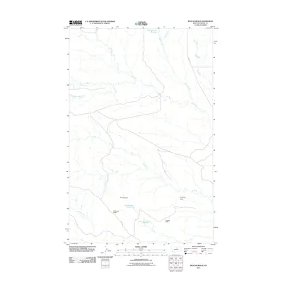
2011 Map of Runyan Bench
USGS Topo · Published 2011About this map
Runyan Bench and Threemile Ridge dominate this northern Montana landscape in Blaine County, where water management is central to the area's geography. The map documents a network of small reservoirs and coulees, including Four O'Clock Reservoir, Lower Hansen Reservoir, and Als Coulee Reservoir, which are vital in this arid environment. Significant watercourses like Cow Creek and Hansen Creek thread through the terrain, while landmarks such as Chimney Butte and Gumbo Butte provide orientation across the high plains. The presence of Birdtail Rd and 3 Mile Rd indicates the sparse but deliberate infrastructure required to navigate these wide-open spaces at the start of the 21st century.
Find a feature on this map
17 named features on this map. Tap any name to fly to it.
Don’t see what you’re looking for? This feature index may not catch every label — zoom into the map to look around manually.
Map Details
Editions of this 2011 Runyan Bench Map
This is the sole edition of this map. No revisions or reprints were ever made.
Other maps of this area

1953 · Havre
USGS Topo · 1:250,000

1954 · Lewistown
USGS Topo · 1:250,000

1956 · Maddux
USGS Topo · 1:62,500

1956 · Rattlesnake
USGS Topo · 1:62,500

1957 · Havre
USGS Topo · 1:250,000

1958 · Havre
USGS Topo · 1:250,000

1959 · Lewistown
USGS Topo · 1:250,000
1985 · Nolan Reservoir
USGS Topo · 1:24,000
1985 · Sandpiper Reservoir
USGS Topo · 1:24,000
1985 · Butch Reservoir
USGS Topo · 1:24,000