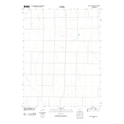
2009 Map of Rush Center SE
USGS Topo · Published 2009About this map
Vaughn stands as the central point of reference in this Pawnee County landscape, situated amidst a grid of rural roads that define the region's agricultural character. The terrain is shaped by the subtle drainage patterns of several seasonal waterways, most notably the winding course of Ash Creek which traverses the central and eastern portions of the map. In the northwestern corner, the headwaters of Otter Creek emerge, while Cocklebur Creek cuts through the southwestern section, illustrating the natural irrigation and topography of the Kansas prairie. Published by the U.S. Geological Survey in 2009, this map documents the established rural boundaries and transportation network of a community defined by its open spaces and creek systems.
Find a feature on this map
4 named features on this map. Tap any name to fly to it.
Don’t see what you’re looking for? This feature index may not catch every label — zoom into the map to look around manually.
Map Details
Editions of this 2009 Rush Center SE Map
This is the sole edition of this map. No revisions or reprints were ever made.
Other maps of this area

1889 · Larned
USGS Topo · 1:125,000

1891 · Larned
USGS Topo · 1:125,000

1955 · Great Bend
USGS Topo · 1:250,000

1957 · Great Bend
USGS Topo · 1:250,000

1958 · Great Bend
USGS Topo · 1:250,000

1966 · Rush Center
USGS Topo · 1:24,000

1966 · Nekoma
USGS Topo · 1:24,000
1966 · Timken
USGS Topo · 1:24,000

1970 · Fort Larned
USGS Topo · 1:24,000
1970 · Rozel
USGS Topo · 1:24,000