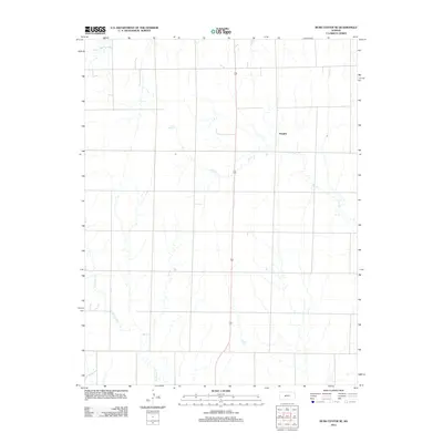
2012 Map of Rush Center SE
USGS Topo · Published 2012About this map
Vaughn stands as the primary community in this rural Pawnee County landscape, situated within a grid of section-line roads that define the region's agricultural character. The topography is shaped by several prominent watercourses, most notably the winding path of Ash Cr which meanders through the central and eastern portions of the map. These drainages, including Cocklebur Cr in the southwest and Otter Cr in the northwest, are the defining natural features in a territory dominated by expansive plains and high-desert farming. The layout of the roads and the orientation of the settlements reflect the systematic land divisions common in the Great Plains, where every mile of road often serves as a lifeline between isolated farmsteads and small crossroads like Vaughn.
Find a feature on this map
4 named features on this map. Tap any name to fly to it.
Don’t see what you’re looking for? This feature index may not catch every label — zoom into the map to look around manually.
Map Details
Editions of this 2012 Rush Center SE Map
This is the sole edition of this map. No revisions or reprints were ever made.
Other maps of this area

1889 · Larned
USGS Topo · 1:125,000

1891 · Larned
USGS Topo · 1:125,000

1955 · Great Bend
USGS Topo · 1:250,000

1957 · Great Bend
USGS Topo · 1:250,000

1958 · Great Bend
USGS Topo · 1:250,000

1966 · Rush Center
USGS Topo · 1:24,000

1966 · Nekoma
USGS Topo · 1:24,000
1966 · Timken
USGS Topo · 1:24,000

1970 · Fort Larned
USGS Topo · 1:24,000
1970 · Rozel
USGS Topo · 1:24,000