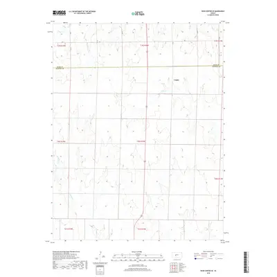
2018 Map of Rush Center SE
USGS Topo · Published 2018About this map
Vaughn sits atop the high plains of Central Kansas, marking a quiet settlement transition between the borders of Rush and Pawnee counties. The landscape is defined by the headwaters and drainage patterns of several intermittent streams, most notably the meandering paths of Ash Cr in the east and Cocklebur Cr to the southwest. This 2018 survey reveals a terrain organized by the Public Land Survey System, where section lines and local thoroughfares like Ave X dictate the rural layout. The absence of dense development highlights the area's agricultural character, preserved in a network of township and range boundaries that have governed this prairie region for generations.
Find a feature on this map
14 named features on this map. Tap any name to fly to it.
Don’t see what you’re looking for? This feature index may not catch every label — zoom into the map to look around manually.
Map Details
Editions of this 2018 Rush Center SE Map
This is the sole edition of this map. No revisions or reprints were ever made.
Other maps of this area

1889 · Larned
USGS Topo · 1:125,000

1891 · Larned
USGS Topo · 1:125,000

1955 · Great Bend
USGS Topo · 1:250,000

1957 · Great Bend
USGS Topo · 1:250,000

1958 · Great Bend
USGS Topo · 1:250,000

1966 · Rush Center
USGS Topo · 1:24,000

1966 · Nekoma
USGS Topo · 1:24,000
1966 · Timken
USGS Topo · 1:24,000

1970 · Fort Larned
USGS Topo · 1:24,000
1970 · Rozel
USGS Topo · 1:24,000