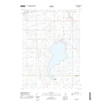
2018 Map of Rush Lake
USGS Topo · Published 2018About this map
Rush Lake dominates this portion of Winnebago County, surrounded by a complex network of wetlands and small agricultural settlements. The eastern shore is particularly well-defined by the community of Wilmoore Heights and the distinctive inlets of Green Bay and Gleason Bay. To the northeast, Waukau sits along the banks of Waukau Cr, while the hamlet of Koro marks the crossroads to the west. This landscape is of significant value to genealogists and local historians, as it preserves the locations of numerous family-named cemeteries including Eureka Cem, Nepeuskun Cem, Krebs Cem, and Loper Cem. The map illustrates a rural Wisconsin environment where the drainage patterns of Henderson Cr and Eightmile Cr dictate the placement of local roads like Koro Rd and Co RD V, showing the long-standing relationship between the marshy terrain and human habitation.
Find a feature on this map
65 named features on this map. Tap any name to fly to it.
Don’t see what you’re looking for? This feature index may not catch every label — zoom into the map to look around manually.
Map Details
Editions of this 2018 Rush Lake Map
This is the sole edition of this map. No revisions or reprints were ever made.
Other maps of this area

1916 · Ripon
USGS Topo · 1:48,000

1918 · Ripon
USGS Topo · 1:62,500

1955 · Green Bay
USGS Topo · 1:250,000

1956 · Ripon
USGS Topo · 1:62,500

1956 · Rosendale
USGS Topo · 1:62,500

1957 · Madison
USGS Topo · 1:250,000

1960 · Madison
USGS Topo · 1:250,000

1961 · Poy Sippi
USGS Topo · 1:62,500

1961 · Oshkosh
USGS Topo · 1:62,500
1961 · Auroraville
USGS Topo · 1:24,000