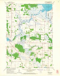
1961 Map of Auroraville
USGS Topo · Published 1966About this map
Willow Creek meanders through the central landscape of this 1961 survey, connecting the settlement of Auroraville to the expansive wetlands of the Poygan Marsh. The area is defined by its low-lying hydrology, where the Pine River and Pumpkinseed Creek feed into Lake Poygan. This environment supported specialized agriculture, evidenced by multiple sites labeled Cranberry Bog. Small rural centers like Fountain Valley and Borth serve as anchors for the surrounding farmsteads, while the local history of the region is preserved in several denominational and community landmarks such as Immanuel Ch, Trinity Ch, and the Welsh Cem. Numerous Gravel Pits and a Sandpit scattered across the township of Aurora indicate the localized extractive industries that operated alongside the region's dairy and cranberry farms during the early 1960s.
Find a feature on this map
24 named features on this map. Tap any name to fly to it.
Don’t see what you’re looking for? This feature index may not catch every label — zoom into the map to look around manually.
Map Details
Editions of this 1961 Auroraville Map
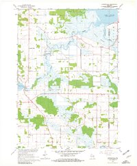
2 editions found
Other maps of this area

1915 · Neshkoro
USGS Topo · 1:48,000

1916 · Ripon
USGS Topo · 1:48,000

1918 · Neshkoro
USGS Topo · 1:62,500

1918 · Ripon
USGS Topo · 1:62,500

1955 · Green Bay
USGS Topo · 1:250,000

1956 · Ripon
USGS Topo · 1:62,500

1957 · Madison
USGS Topo · 1:250,000

1960 · Madison
USGS Topo · 1:250,000

1961 · Poy Sippi
USGS Topo · 1:62,500

1961 · Redgranite
USGS Topo · 1:62,500