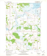
1961 Map of Auroraville
USGS Topo · Published 1981About this map
Poy Sippi and Auroraville anchor this early 1960s survey of eastern Waushara County, where the landscape is defined by the hydrologic transition toward Lake Poygan. The map documents a rural economy still closely tied to its water resources, featuring a Cranberry Bog south of the Willow Creek bottomlands and a Mill Pond at Auroraville. The drainage network, including Pumpkinseed Creek and the Pine River, feeds into the expansive Poygan Marsh, illustrating the complex wetland environment of the Poygan and Rushford borderlands. Genealogists will find significant local value in the clearly marked rural burial grounds such as Sheads Island Cem and Welsh Cem, alongside community centers like Immanuel Ch and Trinity Ch. Numerous gravel pits and sandpits scattered throughout the townships indicate the localized extractive industry supporting the area's road development at this time.
Find a feature on this map
26 named features on this map. Tap any name to fly to it.
Don’t see what you’re looking for? This feature index may not catch every label — zoom into the map to look around manually.
Map Details
Editions of this 1961 Auroraville Map
2 editions found
Other maps of this area

1915 · Neshkoro
USGS Topo · 1:48,000

1916 · Ripon
USGS Topo · 1:48,000

1918 · Neshkoro
USGS Topo · 1:62,500

1918 · Ripon
USGS Topo · 1:62,500

1955 · Green Bay
USGS Topo · 1:250,000

1956 · Ripon
USGS Topo · 1:62,500

1957 · Madison
USGS Topo · 1:250,000

1960 · Madison
USGS Topo · 1:250,000

1961 · Poy Sippi
USGS Topo · 1:62,500

1961 · Redgranite
USGS Topo · 1:62,500