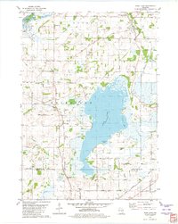
1980 Map of Rush Lake
USGS Topo · Published 1981About this map
The Fox River flows through the northwest corner of this Winnebago County landscape, featuring the historic Eureka Lock No 1 near the settlement of Eureka. This 1980s record documents the extensive marshy borders of Rush Lake, including Green Bay and Gleason Bay. The rural infrastructure is characterized by a high density of family and community burial grounds, such as Eureka Cem, Waukau Cem, Nepeuskun Cem, Krebs Cem, and Loper Cem, which offer significant value for genealogical research in the townships of Rush Ford and Nepeuskun. Transport patterns are defined by the Chicago Milwaukee St Paul and Pacific railroad and an Old Railroad Grade winding through Waukau. The presence of the Wayside Sch and numerous gravel pits suggests a late-century rural economy transitioning toward conservation, as seen in the Waukau Creek County Nature Preserve.
Find a feature on this map
48 named features on this map. Tap any name to fly to it.
Don’t see what you’re looking for? This feature index may not catch every label — zoom into the map to look around manually.
Map Details
Editions of this 1980 Rush Lake Map
This is the sole edition of this map. No revisions or reprints were ever made.
Other maps of this area

1916 · Ripon
USGS Topo · 1:48,000

1918 · Ripon
USGS Topo · 1:62,500

1955 · Green Bay
USGS Topo · 1:250,000

1956 · Ripon
USGS Topo · 1:62,500

1956 · Rosendale
USGS Topo · 1:62,500

1957 · Madison
USGS Topo · 1:250,000

1960 · Madison
USGS Topo · 1:250,000

1961 · Poy Sippi
USGS Topo · 1:62,500

1961 · Oshkosh
USGS Topo · 1:62,500
1961 · Auroraville
USGS Topo · 1:24,000