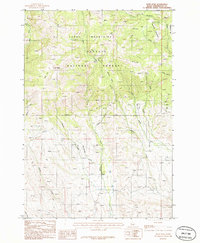
1986 Map of Rush Peak
USGS Topo · Published 1986About this map
The Cuddy Mountains dominate this 1980s terrain, forming a high-elevation landscape within the Payette National Forest. This provisional survey captures the area just after the 1982 field check, documenting a complex network of drainage systems such as Rush Creek and Calamity Creek that carve through the high plateaus. The map serves as a detailed record of the backcountry infrastructure of the era, marking specific summits like Rush Peak and the high-altitude Big Flat.
Find a feature on this map
22 named features on this map. Tap any name to fly to it.
Don’t see what you’re looking for? This feature index may not catch every label — zoom into the map to look around manually.
Map Details
Editions of this 1986 Rush Peak Map
This is the sole edition of this map. No revisions or reprints were ever made.
Other maps of this area

1955 · Baker
USGS Topo · 1:250,000

1957 · Cambridge
USGS Topo · 1:62,500

1957 · Copperfield
USGS Topo · 1:62,500

1957 · Hornet
USGS Topo · 1:62,500

1957 · Sturgill Peak
USGS Topo · 1:62,500

1959 · Baker
USGS Topo · 1:250,000

1980 · McCall
USGS Topo · 1:100,000

1986 · Peck Mountain
USGS Topo · 1:24,000
1986 · Crooked River Point
USGS Topo · 1:24,000
1986 · East of Cambridge
USGS Topo · 1:24,000