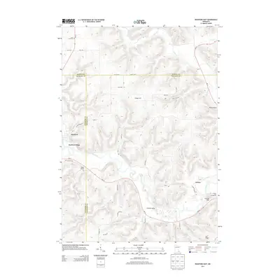
2013 Map of Rushford East
USGS Topo · Published 2013About this map
The Root River carves a deep valley through this corner of Southeast Minnesota, where the borders of Winona, Fillmore, and Houston Counties meet. High bluffs and steep terrain define the area, rising toward landmarks like Vinegar Hill and Cushings Peak. The settlement of Rushford and the surrounding Rushford Village occupy the river bottom, anchored by the junction of Rush Creek and the main river. Rural life is traced through scattered hamlets and family-named landmarks, including the small community of Perkins and Oak Ridge to the south. Local history is preserved in the grounds of Saint Johns Cem and Sherwood Cem, while recreational spaces like Cushon's Peak Campground highlight the valley's modern use. The complex topography is further dissected by smaller tributaries such as Money Cr, Daley Cr, and Ferndale Cr, each creating its own narrow valley, such as Baker Valley and Wiscoy Valley.
Find a feature on this map
42 named features on this map. Tap any name to fly to it.
Don’t see what you’re looking for? This feature index may not catch every label — zoom into the map to look around manually.
Map Details
Editions of this 2013 Rushford East Map
This is the sole edition of this map. No revisions or reprints were ever made.
Other maps of this area

1954 · Lewiston
USGS Topo · 1:62,500

1958 · Houston
USGS Topo · 1:62,500

1958 · La Crosse
USGS Topo · 1:250,000

1961 · La Crosse
USGS Topo · 1:250,000

1965 · La Crosse
USGS Topo · 1:250,000

1965 · Sheldon
USGS Topo · 1:24,000

1965 · Yucatan
USGS Topo · 1:24,000

1965 · Bratsberg
USGS Topo · 1:24,000
1974 · Rushford West
USGS Topo · 1:24,000
1974 · Lewiston
USGS Topo · 1:24,000