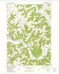
1980 Map of Rushford East
USGS Topo · Published 1980About this map
The Root River winds through this 1980 survey, carving a deep valley through the driftless-style terrain of southeastern Minnesota. Much of the high ground is protected by the Richard J Dorer Memorial Hardwood State Forest, highlighting a landscape where timbered ridges like Oak Ridge overlook fertile agricultural bottoms. The rail corridor of the Chicago Milwaukee St Paul and Pacific follows the river's path, serving the small community of Rushford and the rural stop of Perkins. Evidence of local industry is visible in several scattered sandpits and a quarry, while recreational landmarks such as the Ferndale Country Club and Roadside Park mark the social geography of the era. Genealogists will find the locations of St Johns Cem and Sherwood Cem preserved alongside family-named landmarks like Hovde and Cushings Peak.
Find a feature on this map
28 named features on this map. Tap any name to fly to it.
Don’t see what you’re looking for? This feature index may not catch every label — zoom into the map to look around manually.
Map Details
Editions of this 1980 Rushford East Map
This is the sole edition of this map. No revisions or reprints were ever made.
Other maps of this area

1954 · Lewiston
USGS Topo · 1:62,500

1958 · Houston
USGS Topo · 1:62,500

1958 · La Crosse
USGS Topo · 1:250,000

1961 · La Crosse
USGS Topo · 1:250,000

1965 · La Crosse
USGS Topo · 1:250,000

1965 · Sheldon
USGS Topo · 1:24,000

1965 · Yucatan
USGS Topo · 1:24,000

1965 · Bratsberg
USGS Topo · 1:24,000
1974 · Rushford West
USGS Topo · 1:24,000
1974 · Lewiston
USGS Topo · 1:24,000