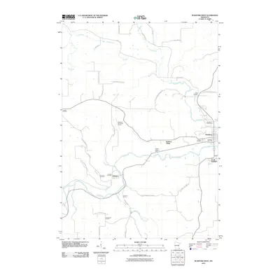
2010 Map of Rushford West
USGS Topo · Published 2010About this map
Peterson and Rushford anchor this detailed study of the Root River valley in Fillmore County during the early 21st century. The landscape is defined by the winding course of the Root River, which is joined by Pine Creek and Rush Creek as they cut through the regional topography. For those researching local heritage, the map identifies numerous family and community landmarks, including several burial grounds such as Arendahl Cemetery, Hungerholdt Cemetery, and the West Grace Cemetery near Peterson. Infrastructure and local industry are marked by the Robert Highum Dam and the Rushford Municipal Airport. The settlement pattern follows the river corridor, with South Rushford and Rushford Village expanding near the confluence of the valley's major waterways.
Find a feature on this map
29 named features on this map. Tap any name to fly to it.
Don’t see what you’re looking for? This feature index may not catch every label — zoom into the map to look around manually.
Map Details
Editions of this 2010 Rushford West Map
This is the sole edition of this map. No revisions or reprints were ever made.
Other maps of this area

1954 · Lewiston
USGS Topo · 1:62,500

1958 · Houston
USGS Topo · 1:62,500

1958 · La Crosse
USGS Topo · 1:250,000

1961 · La Crosse
USGS Topo · 1:250,000

1965 · La Crosse
USGS Topo · 1:250,000

1965 · Yucatan
USGS Topo · 1:24,000

1965 · Bratsberg
USGS Topo · 1:24,000
1965 · Lanesboro
USGS Topo · 1:24,000
1974 · Rushford West
USGS Topo · 1:24,000
1974 · Utica
USGS Topo · 1:24,000
Featured Places
- Rushford, MN
- Rushford Village, MN
- Peterson, MN
- South Rushford, Rushford Village
- Bluffview Park Mobile Home Park, Rushford