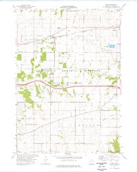
1974 Map of Utica
USGS Topo · Published 1976About this map
The Chicago and North Western corridor defines the northern landscape of this region, connecting the primary settlements of Utica and Lewiston. This mid-1970s survey reveals a balanced environment of agricultural development and conservation, particularly within the Minnesota Memorial Hardwood State Forest, which occupies the central and southern reaches. Small crossroads communities and family-named landmarks are scattered throughout, including Clyde and Fremont, providing critical reference points for genealogists. The map also documents industrial and infrastructure remnants like an Old Railroad Grade and various quarries. Notable local institutions such as the Scottish Ch and several burial grounds including Mt Auburn Cem and Worth Cem anchor the community history of the southern townships.
Find a feature on this map
24 named features on this map. Tap any name to fly to it.
Don’t see what you’re looking for? This feature index may not catch every label — zoom into the map to look around manually.
Map Details
Editions of this 1974 Utica Map
This is the sole edition of this map. No revisions or reprints were ever made.
Other maps of this area

1932 · Cochrane
USGS Topo · 1:62,500

1934 · Plainview
USGS Topo · 1:62,500

1934 · Cochrane
USGS Topo · 1:62,500

1937 · Cochrane
USGS Topo · 1:62,500

1938 · Plainview
USGS Topo · 1:62,500

1953 · Saint Paul
USGS Topo · 1:250,000

1953 · Eau Claire
USGS Topo · 1:250,000

1954 · Chatfield
USGS Topo · 1:62,500

1954 · Lewiston
USGS Topo · 1:62,500

1954 · Mason City
USGS Topo · 1:250,000