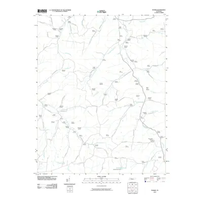
2010 Map of Ruskin
USGS Topo · Published 2010About this map
Yellow Creek and its many tributaries carve through a complex network of hollows in this 2010 survey of the Tennessee landscape. The drainage patterns of Whiteoak Creek, Salmon Branch, and Ennis Branch define the local topography, which is marked by numerous family-named landforms such as Biffle Hollow, Newman Hollow, and Buckeye Hollow. This rural terrain is notable for its high density of small family burial grounds and community graveyards, including the Bethany Cemetery, Etheridge Cemetery, and Skelton Cemetery, which serve as vital markers for genealogical research in this part of the state.
Find a feature on this map
110 named features on this map. Tap any name to fly to it.
Don’t see what you’re looking for? This feature index may not catch every label — zoom into the map to look around manually.
Map Details
Editions of this 2010 Ruskin Map
This is the sole edition of this map. No revisions or reprints were ever made.
Other maps of this area

1931 · Erin
USGS Topo · 1:62,500

1936 · Gorman
USGS Topo · 1:24,000

1936 · Tantrough Hollow
USGS Topo · 1:24,000

1936 · Woolworth
USGS Topo · 1:24,000

1936 · Ruskin
USGS Topo · 1:24,000

1936 · Tennessee City
USGS Topo · 1:24,000

1936 · Dickson
USGS Topo · 1:24,000
1952 · Mc Ewen
USGS Topo · 1:24,000
1952 · Woolworth
USGS Topo · 1:24,000

1953 · Dickson
USGS Topo · 1:24,000