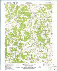
1979 Map of Russ
USGS Topo · Published 1980About this map
The Osage Fork Gasconade River meanders across this rural Laclede County landscape, defining the topography of central Missouri in the late 1970s. This survey records a region characterized by small rural settlements like Russ and Orla, alongside a dense network of country churches and family burial grounds including New Hope Ch and Whitson Cem. The terrain is famously subterranean, featuring several notable karst formations such as Saltpeter Cave, Bat Cave, and the significant Big Spring near the southern boundary. Much of the northeast is protected within the Osage Fork State Forest, while the rest of the quadrangle is divided into the civil townships of Lebanon, Osage, Washington, and Franklin. The map provides a precise view of the road network and property boundaries just before modern development altered these traditional Ozark communities.
Find a feature on this map
38 named features on this map. Tap any name to fly to it.
Don’t see what you’re looking for? This feature index may not catch every label — zoom into the map to look around manually.
Map Details
Editions of this 1979 Russ Map
This is the sole edition of this map. No revisions or reprints were ever made.
Other maps of this area

1931 · Manes
USGS Topo · 1:48,000

1941 · Manes
USGS Topo · 1:62,500

1941 · Lebanon
USGS Topo · 1:62,500

1943 · Lebanon
USGS Topo · 1:62,500

1943 · Manes
USGS Topo · 1:62,500

1943 · Drynob
USGS Topo · 1:62,500

1954 · Springfield
USGS Topo · 1:250,000

1954 · Drynob
USGS Topo · 1:62,500

1954 · Drew
USGS Topo · 1:24,000
1954 · Drynob
USGS Topo · 1:24,000