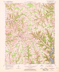
1954 Map of Russell Springs
USGS Topo · Published 1970About this map
Russell Springs serves as the primary hub of this south-central Kentucky landscape, appearing here in the mid-1950s just as the regional topography was being transformed by the recent impoundment of the Cumberland River. The southern edge of the map reveals the newly formed Lake Cumberland, its waters filling the deep valleys of the Caney Fork and Clear Fork. The surrounding ridges, such as Half Acre Ridge and Beckham Ridge, are densely populated with the infrastructure of a rural society, including numerous small schools like Central High Sch and Half Acre Sch. Scattered settlements like Webbs Cross Roads and Jericho are connected by a network of ridge-top roads and creek-side dwellings. This survey captures a moment when traditional agrarian patterns, evidenced by remote houses of worship like Whites Chapel and French Valley Ch, began to intersect with modern developments like the town's Airstrip and Sewage Disposal facility.
Find a feature on this map
65 named features on this map. Tap any name to fly to it.
Don’t see what you’re looking for? This feature index may not catch every label — zoom into the map to look around manually.
Map Details
Editions of this 1954 Russell Springs Map
2 editions found
Other maps of this area

1911 · Monticello
USGS Topo · 1:62,500

1914 · Monticello
USGS Topo · 1:62,500

1953 · Phil
USGS Topo · 1:24,000

1953 · Montpelier
USGS Topo · 1:24,000

1953 · Creelsboro
USGS Topo · 1:24,000

1953 · Jamestown
USGS Topo · 1:24,000

1953 · Dunnville
USGS Topo · 1:24,000

1954 · Jabez
USGS Topo · 1:24,000

1954 · Knifley
USGS Topo · 1:24,000

1954 · Russell Springs
USGS Topo · 1:24,000