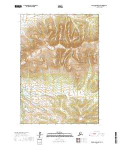
2017 Map of Russian Mission D-8 SW
USGS Topo · Published 2017About this map
Mt Okumiak dominates the northern reaches of this territory, where the interior of the Kusilvak Census Area transitions from high peaks to complex drainage systems. The landscape is defined by a dense network of watercourses, including King Cr and Bernhard Cr in the north, which flow through valleys carved into the high terrain. To the south, Engineer Hill stands as a prominent landmark above the wetlands and meandering paths of Spruce Cr and E Fork Spruce Cr.
Find a feature on this map
21 named features on this map. Tap any name to fly to it.
Don’t see what you’re looking for? This feature index may not catch every label — zoom into the map to look around manually.
Map Details
Editions of this 2017 Russian Mission D-8 SW Map
This is the sole edition of this map. No revisions or reprints were ever made.
Other maps of this area

1947 · Russian Mission
USGS Topo · 1:250,000

1950 · Russian Mission
USGS Topo · 1:250,000

1951 · Marshall
USGS Topo · 1:250,000

1952 · Russian Mission C-8
USGS Topo · 1:63,360
1952 · Russian Mission D-8
USGS Topo · 1:63,360

1952 · Marshall C-1
USGS Topo · 1:63,360
1952 · Marshall D-1
USGS Topo · 1:63,360

1954 · Marshall
USGS Topo · 1:250,000

1980 · Russian Mission
USGS Topo · 1:250,000
2017 · Russian Mission D-8 NW
USGS Topo · 1:25,000