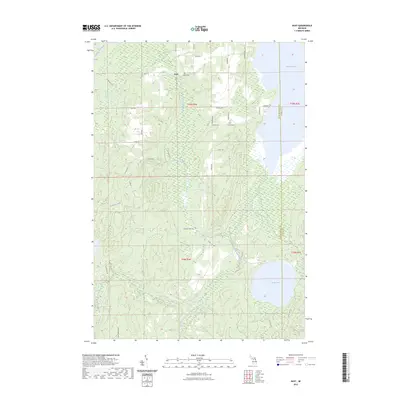
2023 Map of Rust
USGS Topo · Published 2023About this map
Rust sits at the northern edge of this township survey, a settlement defined by its proximity to the Rust Cem and a dense network of local roads. The landscape is dominated by complex hydrography, where the Thunder Bay River and its Upper South Branch wind through wetlands and forest. Large water bodies such as Turtle Lake in the southeast and the southern reaches of Fletcher Pond in the northeast dictate the regional geography. This modern mapping reflects a quiet interior of Michigan, where seasonal trails like Camp Domino Trl and Fletcher Trl provide access to the various creeks, including Weber Creek, Turtle Creek, and Cole Creek. The boundary between Montmorency and Alpena counties runs north-south through the eastern portion of the map, bisecting the drainage areas that feed into the larger river systems.
Find a feature on this map
33 named features on this map. Tap any name to fly to it.
Don’t see what you’re looking for? This feature index may not catch every label — zoom into the map to look around manually.
Map Details
Editions of this 2023 Rust Map
This is the sole edition of this map. No revisions or reprints were ever made.
Other maps of this area

1954 · Traverse City
USGS Topo · 1:250,000

1954 · Tawas City
USGS Topo · 1:250,000

1954 · Alpena
USGS Topo · 1:250,000

1955 · Atlanta
USGS Topo · 1:62,500

1955 · Comins
USGS Topo · 1:62,500

1955 · Hillman
USGS Topo · 1:62,500

1955 · Cheboygan
USGS Topo · 1:250,000

1957 · Alpena
USGS Topo · 1:250,000

1958 · Cheboygan
USGS Topo · 1:250,000

1958 · Traverse City
USGS Topo · 1:250,000