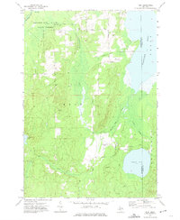
1972 Map of Rust
USGS Topo · Published 1975About this map
Thunder Bay River State Forest dominates the terrain of this 1972 survey, illustrating a landscape defined by timber history and hydrological networks on the border of Montmorency and Alpena counties. The small settlement of Rust and the nearby Rust Sch serve as the primary local hubs, while an Old Railroad Grade cutting across the northern half of the sheet signals the region's industrial past. The area is heavily marked by water, from the expansive Fletcher Pond and Turtle Lake to the winding South Branch Thunder Bay River. Evidence of private land management and aviation is visible at the Turtle Lake Club Airport, highlighting how the territory has been utilized for recreation and resource extraction beyond traditional agriculture. Numerous Gravel Pits are scattered throughout the quadrangle, indicating active geological harvesting alongside protected forest lands.
Find a feature on this map
25 named features on this map. Tap any name to fly to it.
Don’t see what you’re looking for? This feature index may not catch every label — zoom into the map to look around manually.
Map Details
Editions of this 1972 Rust Map
This is the sole edition of this map. No revisions or reprints were ever made.
Other maps of this area

1954 · Traverse City
USGS Topo · 1:250,000

1954 · Tawas City
USGS Topo · 1:250,000

1954 · Alpena
USGS Topo · 1:250,000

1955 · Atlanta
USGS Topo · 1:62,500

1955 · Comins
USGS Topo · 1:62,500

1955 · Hillman
USGS Topo · 1:62,500

1955 · Cheboygan
USGS Topo · 1:250,000

1957 · Alpena
USGS Topo · 1:250,000

1958 · Cheboygan
USGS Topo · 1:250,000

1958 · Traverse City
USGS Topo · 1:250,000