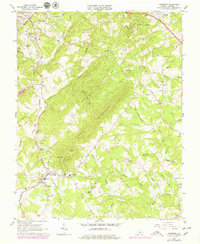
1963 Map of Rustburg
USGS Topo · Published 1979About this map
Rustburg serves as a central hub in this Virginia landscape, situated where local roads and the Norfolk And Western railroad intersect south of Bocock. The map reveals a community defined by its institutional and spiritual anchors, from the County High Sch to a high density of rural houses of worship such as Providence Ch, Immanuel Ch, and Indian Hill Ch. The presence of the State Prison Camp and nearby Sewage Disposal facility near Galloway Creek indicates the development of public infrastructure serving the county during the mid-20th century.
Find a feature on this map
67 named features on this map. Tap any name to fly to it.
Don’t see what you’re looking for? This feature index may not catch every label — zoom into the map to look around manually.
Map Details
Editions of this 1963 Rustburg Map
4 editions found
Other maps of this area

1892 · Lynchburg
USGS Topo · 1:125,000

1892 · Appomattox
USGS Topo · 1:125,000

1944 · Lynchburg
USGS Topo · 1:62,500

1947 · Roanoke
USGS Topo · 1:250,000

1950 · Lynchburg
USGS Topo · 1:62,500

1956 · Brookneal
USGS Topo · 1:62,500

1956 · Gladys
USGS Topo · 1:62,500

1958 · Appomattox
USGS Topo · 1:62,500

1959 · Roanoke
USGS Topo · 1:250,000

1963 · Roanoke
USGS Topo · 1:250,000