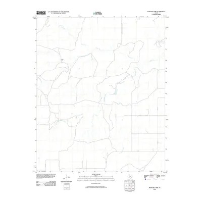
2010 Map of Rustler Camp
USGS Topo · Published 2010About this map
Rustler Camp stands as a focal point in this portion of Dickens County, Texas, where the landscape is defined by the complex drainage of the Tongue River and its several tributaries. The area's hydrology is intricately mapped, showing the paths of Wolf Creek, Rustler Creek, and the winding Grapevine Creek. These watercourses create a dissected terrain that has historically shaped the local road network and ranching boundaries.
Find a feature on this map
14 named features on this map. Tap any name to fly to it.
Don’t see what you’re looking for? This feature index may not catch every label — zoom into the map to look around manually.
Map Details
Editions of this 2010 Rustler Camp Map
This is the sole edition of this map. No revisions or reprints were ever made.
Other maps of this area

1954 · Lubbock
USGS Topo · 1:250,000

1965 · Wake
USGS Topo · 1:24,000

1966 · McAdoo
USGS Topo · 1:24,000

1967 · Dickens North
USGS Topo · 1:24,000

1967 · Haystack Mountain
USGS Topo · 1:24,000

1968 · Mac Bain
USGS Topo · 1:24,000

1968 · Roaring Springs
USGS Topo · 1:24,000

1968 · Rustler Camp
USGS Topo · 1:24,000
1968 · Dougherty
USGS Topo · 1:24,000

1968 · Afton
USGS Topo · 1:24,000