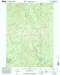
1997 Map of Rustler Peak
USGS Topo · Published 2000About this map
Rustler Peak and its Rustler Lookout dominate this high-elevation landscape within the Rogue River National Forest. The 1990s terrain is defined by a network of creeks like Titanic Creek and Deception Creek that feed into the South Fork Rogue River. In the eastern portion of the sheet, the Sky Lakes Wilderness preserves a cluster of alpine water bodies including Round Lake, Beal Lake, and the North Blue Lake Group. Evidence of early high-country utility appears at Parker Meadows and Sheep Camp Glade, reflecting the long history of summer grazing in these mountains. The Pacific Crest National Scenic Trail traverses the southeast corner, crossing the boundary between Jackson and Klamath counties near Buck Basin.
Find a feature on this map
51 named features on this map. Tap any name to fly to it.
Don’t see what you’re looking for? This feature index may not catch every label — zoom into the map to look around manually.
Map Details
Editions of this 1997 Rustler Peak Map
This is the sole edition of this map. No revisions or reprints were ever made.
Other maps of this area

1891 · Ashland
USGS Topo · 1:250,000

1893 · Ashland
USGS Topo · 1:250,000

1897 · Ashland
USGS Topo · 1:250,000

1955 · Lake O' Woods
USGS Topo · 1:62,500

1955 · Rustler Peak
USGS Topo · 1:62,500

1955 · Mt. Mc Loughlin
USGS Topo · 1:62,500

1955 · Pelican Butte
USGS Topo · 1:62,500

1955 · Medford
USGS Topo · 1:250,000

1957 · Medford
USGS Topo · 1:250,000

1958 · Medford
USGS Topo · 1:250,000