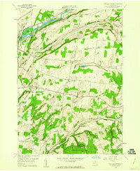
1959 Map of Rutland Center
USGS Topo · Published 1960About this map
The Black River corridor defines the northern edge of this Jefferson County landscape, where the New York Central railroad tracks parallel the water near Huntingtonville. The terrain rises sharply to the south toward Rutland Hollow and Rutland Hill, a region marked by a network of family-named roads such as Hadcock Road and Staplin Road. Small crossroads communities and post offices anchor the rural economy, notably Tylersville and Burrs Mills, which sits near the falls of North Branch Sandy Creek.
Find a feature on this map
66 named features on this map. Tap any name to fly to it.
Don’t see what you’re looking for? This feature index may not catch every label — zoom into the map to look around manually.
Map Details
Editions of this 1959 Rutland Center Map
2 editions found
Other maps of this area

1895 · Watertown
USGS Topo · 1:62,500

1898 · Watertown
USGS Topo · 1:62,500

1902 · Carthage
USGS Topo · 1:62,500

1903 · Theresa
USGS Topo · 1:62,500

1904 · Carthage
USGS Topo · 1:62,500

1908 · Watertown
USGS Topo · 1:62,500

1909 · Watertown
USGS Topo · 1:62,500

1911 · Antwerp
USGS Topo · 1:62,500

1942 · Copenhagen
USGS Topo · 1:24,000
1943 · Barnes Corners
USGS Topo · 1:31,680