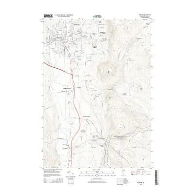
2015 Map of Rutland
USGS Topo · Published 2015About this map
Rutland serves as the primary urban center for this Vermont landscape, surrounded by residential developments like Marolin Acres and Killington Heights. The terrain transitions sharply from the Otter Creek valley into the Green Mountains to the east, where the Appalachian National Scenic Trail winds through the highlands near Bald Mtn. This intersection of transit and topography is marked by significant engineering and historical sites, including the Brown Covered Bridge and Kingsley Covered Bridge spanning the local waterways. Genealogists will find a high density of burial grounds throughout the quadrangle, from the West Street Cem in the city to smaller family and community plots such as the Spafford Cem and Lydias-Wheelerville Road Cem. The southern reach of the map features the Rutland-Southern Vermont Regional Airport and the dramatic Clarendon Gorge, highlighting the area's mix of modern infrastructure and natural landmarks.
Find a feature on this map
57 named features on this map. Tap any name to fly to it.
Don’t see what you’re looking for? This feature index may not catch every label — zoom into the map to look around manually.
Map Details
Editions of this 2015 Rutland Map
This is the sole edition of this map. No revisions or reprints were ever made.
Other maps of this area

1891 · Rutland
USGS Topo · 1:62,500

1893 · Wallingford
USGS Topo · 1:62,500

1893 · Rutland
USGS Topo · 1:62,500

1894 · Pawlet
USGS Topo · 1:62,500

1895 · Castleton
USGS Topo · 1:62,500

1897 · Pawlet
USGS Topo · 1:62,500

1897 · Castleton
USGS Topo · 1:62,500

1903 · Mettawee
USGS Topo · 1:125,000

1944 · Proctor
USGS Topo · 1:31,680
1946 · Proctor
USGS Topo · 1:31,680