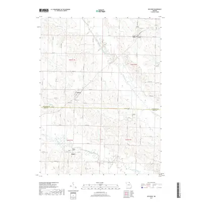
2017 Map of Rutledge
USGS Topo · Published 2017About this map
The agrarian reaches of Scotland and Knox counties are defined by the convergence of the three forks of the Fabius River, creating a rolling landscape of timbered draws and productive bottomlands. The town of Rutledge serves as a central hub, where State Hwy A and several local routes like Blaine Rd intersect near the Pauline Cem. To the north, the twin communities of Gorin and South Gorin sit along the drainage of the North Fabius River, illustrating a pattern of settlement tied closely to the high ground between these major waterways.
Find a feature on this map
72 named features on this map. Tap any name to fly to it.
Don’t see what you’re looking for? This feature index may not catch every label — zoom into the map to look around manually.
Map Details
Editions of this 2017 Rutledge Map
This is the sole edition of this map. No revisions or reprints were ever made.
Other maps of this area
1903 · Kahoka
USGS Topo · 1:125,000
1903 · Edina
USGS Topo · 1:125,000
1950 · Colony
USGS Topo · 1:24,000
1951 · Colony
USGS Topo · 1:24,000
1951 · Wyaconda
USGS Topo · 1:24,000
1951 · Deer Ridge
USGS Topo · 1:24,000

1954 · Centerville
USGS Topo · 1:250,000
1957 · Centerville
USGS Topo · 1:250,000
1958 · Centerville
USGS Topo · 1:250,000
1958 · Burlington
USGS Topo · 1:250,000