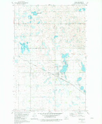
1981 Map of Ryder
USGS Topo · Published 1981About this map
Ryder serves as the central hub of this North Dakota prairie landscape, situated where the Soo Line railroad cuts diagonally across the terrain. The settlement pattern is defined by the grid-based township boundaries of Anna, Ryder, Hidden Wood, and Line. Beyond the town site, the geography is heavily influenced by conservation efforts, featuring several sections designated as National Waterfowl Production Area. These protected wetlands and small water bodies characterize the northern and central portions of the map, while local infrastructure is marked by the Ryder Cem and scattered Gravel Pit locations. The proximity of the Sew Disp Ponds to the town center highlights the localized municipal development during the early 1980s.
Find a feature on this map
11 named features on this map. Tap any name to fly to it.
Don’t see what you’re looking for? This feature index may not catch every label — zoom into the map to look around manually.
Map Details
Editions of this 1981 Ryder Map
This is the sole edition of this map. No revisions or reprints were ever made.
Other maps of this area

1954 · Minot
USGS Topo · 1:250,000

1954 · McClusky
USGS Topo · 1:250,000

1956 · Blue Hill
USGS Topo · 1:24,000

1956 · Douglas West
USGS Topo · 1:24,000

1956 · Roseglen
USGS Topo · 1:24,000

1958 · McClusky
USGS Topo · 1:250,000

1958 · Minot
USGS Topo · 1:250,000

1980 · Minot
USGS Topo · 1:100,000

1980 · Lake Vernon
USGS Topo · 1:24,000

1980 · Plaza SE
USGS Topo · 1:24,000