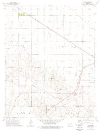
1975 Map of Ryus
USGS Topo · Published 1976About this map
The Cimarron River winds through the southern portion of this landscape, carving through a region defined by industrial infrastructure and agricultural activity. The small settlement of Ryus sits near the northern boundary, while the tracks of the Atchison Topeka and Santa Fe railroad bisect the terrain diagonally, serving as a primary transit corridor. This era was marked by significant energy extraction, evidenced by the dense concentration of Gas Wells and the expansive Oil and Gas Field that spreads across the plains.
Find a feature on this map
24 named features on this map. Tap any name to fly to it.
Don’t see what you’re looking for? This feature index may not catch every label — zoom into the map to look around manually.
Map Details
Editions of this 1975 Ryus Map
This is the sole edition of this map. No revisions or reprints were ever made.
Other maps of this area

1891 · Larned
USGS Topo · 1:125,000

1896 · Garden
USGS Topo · 1:125,000

1900 · Lakin
USGS Topo · 1:125,000

1944 · Moscow
USGS Topo · 1:62,500

1945 · Moscow
USGS Topo · 1:62,500

1955 · Dodge City
USGS Topo · 1:250,000

1958 · Dodge City
USGS Topo · 1:250,000

1959 · Dodge City
USGS Topo · 1:250,000

1959 · Hickok
USGS Topo · 1:24,000

1960 · Hickok SE
USGS Topo · 1:24,000