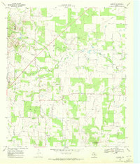
1969 Map of Sabanno
USGS Topo · Published 1972About this map
The Sabanno River carves a winding path through this portion of the Texas plains, defining a landscape marked by the transition from ranching to mid-century petroleum and mineral extraction. Sabanno serves as the central hub of the area, while the surrounding countryside is dotted with numerous oil and gas wells, interconnected by a sprawling network of pipelines and serviced by a dedicated Pumping Station. These industrial features sit alongside established rural landmarks, including the prominent Coyote Peak and multiple Gravel Pits that suggest a high degree of local resource exploitation during the late 1960s.
Find a feature on this map
17 named features on this map. Tap any name to fly to it.
Don’t see what you’re looking for? This feature index may not catch every label — zoom into the map to look around manually.
Map Details
Editions of this 1969 Sabanno Map
This is the sole edition of this map. No revisions or reprints were ever made.
Other maps of this area

1894 · Eastland
USGS Topo · 1:125,000

1931 · Baird
USGS Topo · 1:125,000

1932 · Baird
USGS Topo · 1:125,000

1954 · Abilene
USGS Topo · 1:250,000

1958 · Abilene
USGS Topo · 1:250,000
1960 · Cross Cut
USGS Topo · 1:24,000
1966 · Rising Star
USGS Topo · 1:24,000

1966 · Scranton
USGS Topo · 1:24,000

1966 · Putnam South
USGS Topo · 1:24,000

1966 · Cisco South
USGS Topo · 1:24,000