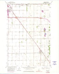
1964 Map of Sabin
USGS Topo · Published 1980About this map
The Burlington Northern railroad cuts a diagonal line across this Clay County landscape, connecting the agricultural hubs of Sabin and Dilworth. In the northwest, the edge of Moorhead shows signs of mid-century development, including the Moorhead Airport and proximity to the industrial Finkle area. This map documents a period of transition where traditional Red River Valley farming meets modern infrastructure, evidenced by the extensive network of drainage systems like County Ditch No 41 and County Ditch No 9. The meandering path of the Buffalo River and its South Branch contrasts with the rigid grid of townships like Kurtz and Elmwood. Distinctive local landmarks such as the Dragstrip north of Sabin and several Sandpits near the river highlight the era's recreational and industrial use of the land.
Find a feature on this map
21 named features on this map. Tap any name to fly to it.
Don’t see what you’re looking for? This feature index may not catch every label — zoom into the map to look around manually.
Map Details
Editions of this 1964 Sabin Map
3 editions found
Other maps of this area

1895 · Fargo
USGS Topo · 1:125,000

1897 · Fargo
USGS Topo · 1:125,000

1953 · Fargo
USGS Topo · 1:250,000

1956 · Fargo
USGS Topo · 1:250,000

1959 · Fargo North
USGS Topo · 1:24,000

1959 · Fargo South
USGS Topo · 1:24,000

1959 · Hickson
USGS Topo · 1:24,000

1964 · Sabin
USGS Topo · 1:24,000

1964 · Baker
USGS Topo · 1:24,000

1964 · Dilworth
USGS Topo · 1:24,000