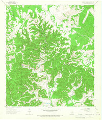
1964 Map of Sabinal Canyon
USGS Topo · Published 1967About this map
Sabinal Canyon defines this portion of the Texas Hill Country, where the landscape is carved by a complex network of seasonal creeks and prongs. The Sabinal River winds through the central valley, flanked by steep ridges like Wedgeworth Hill and numerous named drainages including Marler Creek and Jernigan Creek. The presence of a remote Landing Strip and multiple Jeep Trails suggests the isolated nature of the ranching operations and hunting grounds in this region during the mid-1960s.
Find a feature on this map
28 named features on this map. Tap any name to fly to it.
Don’t see what you’re looking for? This feature index may not catch every label — zoom into the map to look around manually.
Map Details
Editions of this 1964 Sabinal Canyon Map
2 editions found
Other maps of this area

1954 · San Antonio
USGS Topo · 1:250,000

1956 · Tarpley
USGS Topo · 1:62,500

1956 · Tuff
USGS Topo · 1:62,500

1956 · Utopia
USGS Topo · 1:62,500

1957 · San Antonio
USGS Topo · 1:250,000

1964 · Hillcrest Ranch
USGS Topo · 1:24,000

1964 · Circle Bluff
USGS Topo · 1:24,000

1964 · Sabinal Canyon
USGS Topo · 1:24,000

1964 · Well Hollow
USGS Topo · 1:24,000

1964 · Diamond S Ranch
USGS Topo · 1:24,000