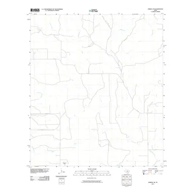
2010 Map of Sabinal NE
USGS Topo · Published 2010About this map
Glasscock Field anchors the southern portion of this landscape in Medina County, marking a localized human footprint amidst an intricate network of Texas waterways. The terrain is defined by the dendritic patterns of several major drainages, including the meandering path of Seco Creek and the southern reaches of Cedar Creek. To the east, Parkers Creek cuts through the territory, while smaller tributaries like Little Comanche Creek and Rancheros Creek highlight the seasonal hydrology of this region. Transportation in the early 21st century is represented by a web of rural routes such as Fm 1796 and Co Rd 312, which connect isolated properties and ranch lands. The map illustrates a rural Texas environment where the natural flow of water remains the primary structural element of the land.
Find a feature on this map
13 named features on this map. Tap any name to fly to it.
Don’t see what you’re looking for? This feature index may not catch every label — zoom into the map to look around manually.
Map Details
Editions of this 2010 Sabinal NE Map
This is the sole edition of this map. No revisions or reprints were ever made.
Other maps of this area

1954 · San Antonio
USGS Topo · 1:250,000

1956 · Sabinal
USGS Topo · 1:62,500

1956 · New Fountain
USGS Topo · 1:62,500

1956 · Tarpley
USGS Topo · 1:62,500

1956 · Bandera
USGS Topo · 1:62,500

1957 · San Antonio
USGS Topo · 1:250,000
1969 · Twin Hollow
USGS Topo · 1:24,000
1969 · Texas Mountain
USGS Topo · 1:24,000

1969 · Sabinal NE
USGS Topo · 1:24,000

1969 · Comanche Waterhole
USGS Topo · 1:24,000