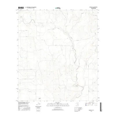
2016 Map of Sabinal NE
USGS Topo · Published 2016About this map
Seco Creek and its many tributaries carve through this portion of Medina County, defining a landscape of complex drainage patterns and winding ranch roads. The waterway, labeled both as Seco Cr and Seco Creek, dominates the central and eastern sections, joined by smaller systems like Cedar Cr and Rocky Cr. This 2016 survey shows the area's continued reliance on a network of farm-to-market and private routes, such as FM 1796 and Ranch Rd, which navigate the elevation changes between the creek beds.
Find a feature on this map
20 named features on this map. Tap any name to fly to it.
Don’t see what you’re looking for? This feature index may not catch every label — zoom into the map to look around manually.
Map Details
Editions of this 2016 Sabinal NE Map
This is the sole edition of this map. No revisions or reprints were ever made.
Other maps of this area

1954 · San Antonio
USGS Topo · 1:250,000

1956 · Sabinal
USGS Topo · 1:62,500

1956 · New Fountain
USGS Topo · 1:62,500

1956 · Tarpley
USGS Topo · 1:62,500

1956 · Bandera
USGS Topo · 1:62,500

1957 · San Antonio
USGS Topo · 1:250,000
1969 · Twin Hollow
USGS Topo · 1:24,000
1969 · Texas Mountain
USGS Topo · 1:24,000

1969 · Sabinal NE
USGS Topo · 1:24,000

1969 · Comanche Waterhole
USGS Topo · 1:24,000