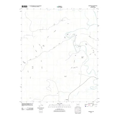
2010 Map of Sabinoso
USGS Topo · Published 2010About this map
Sabinoso and the winding canyons of San Miguel County define this 2010 USGS survey, where the confluence of the Mora River and Canadian River cuts through a landscape of high mesas and deep drainages. The area is marked by a history of ranching and resource extraction, evidenced by the Lujan Cattle Company and the Lujan Ranch along the riverbanks, alongside numerous claims such as the Windy Number Nine Mine and the Hunt Oil Company Mine. Local genealogy is anchored by small settlements and family sites like Ancon, Medina, and Sanchez, as well as the Cañon Largo Cemetery.
Find a feature on this map
37 named features on this map. Tap any name to fly to it.
Don’t see what you’re looking for? This feature index may not catch every label — zoom into the map to look around manually.
Map Details
Editions of this 2010 Sabinoso Map
This is the sole edition of this map. No revisions or reprints were ever made.
Other maps of this area

1892 · Watrous
USGS Topo · 1:125,000

1894 · Watrous
USGS Topo · 1:125,000

1954 · Santa Fe
USGS Topo · 1:250,000

1958 · Santa Fe
USGS Topo · 1:250,000

1964 · Canon Ancho
USGS Topo · 1:24,000

1971 · Alamito
USGS Topo · 1:24,000

1971 · Canon Olguin
USGS Topo · 1:24,000

1971 · Canon Encierro
USGS Topo · 1:24,000

1972 · Arroyo Alamocito
USGS Topo · 1:24,000
1972 · Maes
USGS Topo · 1:24,000